North Painshire: Difference between revisions
Jump to navigation
Jump to search
No edit summary |
No edit summary |
||
| Line 29: | Line 29: | ||
|loctext = <!--text description of location of country--> | |loctext = <!--text description of location of country--> | ||
|alt_map = <!--alt text for map--> | |alt_map = <!--alt text for map--> | ||
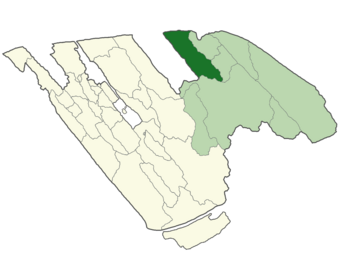
|map_caption = | |map_caption = Painshire in dark green, Eastern Modenshia in light green, and rest of Modenshia in beige. | ||
|image_map2 = <!--Another map, if required--> | |image_map2 = <!--Another map, if required--> | ||
|alt_map2 = <!--alt text for second map--> | |alt_map2 = <!--alt text for second map--> | ||
Revision as of 07:56, 21 June 2023
The Kingdom of North Painshire is a autonomous administrative division located in northeast Modenshia
North Painshire is a mix of Hispanic and Anglo-Saxon culture inside the tiny area
North Painshire | |
|---|---|
 Painshire in dark green, Eastern Modenshia in light green, and rest of Modenshia in beige. | |
| Demonym(s) | Shiric |
| Government | Monarchy |
• King | Spider |
• Prince | Yutrishi |
| Population | |
• Census | 3 |
| Capital | Greater Shireton |
|---|---|
| Largest city | East Drumchapel |
| Official languages | English, Spanish, Britannian. |
| Demonym | Shiric, Pantonian |
| Government | Monarchy |
| • King | Spider |
| • Queen | N/A |
| • Prince | Yutrishi |
| Legislature | Parliament |
| Establishment | 15th of November, 2022 |
| Population | |
| • Citizens | 3 |
| Currency | Pantonian Spleef ₽/ Shiric Pound Б |


