North Painshire: Difference between revisions
No edit summary |
No edit summary |
||
| (12 intermediate revisions by 3 users not shown) | |||
| Line 1: | Line 1: | ||
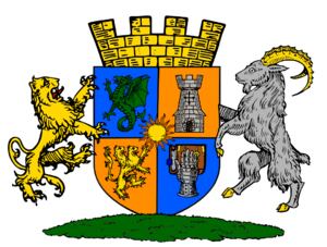
[[File:Coat of Arms.png|thumb|The Coat of Arms of North Painshire]] | [[File:Coat of Arms of Norþwayis Panshirisk-Trotsbeeolandsk.png|thumb|The Coat of Arms of North Painshire]] | ||
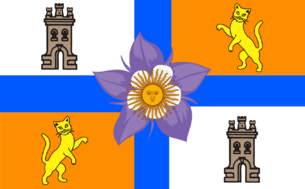
[[File: | [[File:Official flag of North Painshire and Trottingsbeorgen.png|thumb|305x305px|The official flag of North Painshire and Trottingsbeorgen]] | ||
The Kingdom of North Painshire is a autonomous administrative division located in northeast Modenshia | The Kingdom of North Painshire and Trottingsbeorgen (Druhwelandsk og Norþwayis Panshirisk-Trotsbeeolandsk) is a autonomous administrative division located in northeast Modenshia | ||
North Painshire is a mix of Hispanic and Anglo-Saxon culture inside the tiny area | North Painshire is a mix of Hispanic and Anglo-Saxon culture inside the tiny area | ||
----North Painshire annexed the former Takayan province of Trottingsbeorgen on the 14th of July, 2023 after the collapse of Takaya. To keep a part of Takaya alive King Spider decided to make a unified state like Austria-Hungary or Brandenburg-Prussia. Changing it from being just North Painshire to North Painshire and Trottinsbeorgen (shortened to NP-T, NPT, or just NP) | |||
Shortly after the collapse the CTTO (Central Takayan Treaty Organization) made up of former provinces of Takaya. The CTTO went to a short lived war with the Takayan Provincial Government who wanted to restore Takaya. | |||
{{Infobox country | {{Infobox country | ||
|micronation = <!--yes if a micronation--> | |micronation = <!--yes if a micronation--> | ||
|conventional_long_name = | |conventional_long_name = North Painshire and Trottingsbeorgen | ||
|native_name = <!--Country's name (usually full name) in its official/defacto language(s), hence in italics (double quotemarks)--> | |native_name = <!--Country's name (usually full name) in its official/defacto language(s), hence in italics (double quotemarks)--> | ||
|common_name = | |common_name =North Painshire | ||
|image_flag =Flag of North Painshire.png | |||
|image_flag = | |||
|alt_flag = <!--alt text for flag (text shown when pointer hovers over flag)--> | |alt_flag = <!--alt text for flag (text shown when pointer hovers over flag)--> | ||
|flag_border = <!--set to no to disable border around the flag--> | |flag_border = <!--set to no to disable border around the flag--> | ||
| Line 18: | Line 20: | ||
|alt_flag2 = <!--alt text for second flag--> | |alt_flag2 = <!--alt text for second flag--> | ||
|flag2_border = <!--set to no to disable border around the flag--> | |flag2_border = <!--set to no to disable border around the flag--> | ||
|image_coat = | |image_coat = Coat of Arms.png | ||
|alt_coat = <!--alt text for coat of arms--> | |alt_coat = <!--alt text for coat of arms--> | ||
|symbol_type = <!--emblem, seal, etc (if not a coat of arms)--> | |symbol_type = <!--emblem, seal, etc (if not a coat of arms)--> | ||
| Line 27: | Line 29: | ||
|other_symbol_type = <!--Use if a further symbol exists, e.g. hymn--> | |other_symbol_type = <!--Use if a further symbol exists, e.g. hymn--> | ||
|other_symbol = | |other_symbol = | ||
|image_map = | |image_map = NorthPainshireModenshiaMap.png | ||
|loctext = <!--text description of location of country--> | |loctext = <!--text description of location of country--> | ||
|alt_map = <!--alt text for map--> | |alt_map = <!--alt text for map--> | ||
|map_caption = | |map_caption = Painshire in dark green, Eastern Modenshia in light green, and rest of Modenshia in beige. | ||
|image_map2 = <!--Another map, if required--> | |image_map2 = <!--Another map, if required--> | ||
|alt_map2 = <!--alt text for second map--> | |alt_map2 = <!--alt text for second map--> | ||
| Line 54: | Line 56: | ||
|religion_year = <!--Year of religion data (if provided)--> | |religion_year = <!--Year of religion data (if provided)--> | ||
|religion_ref = <!--(for any ref/s to associate with religion data)--> | |religion_ref = <!--(for any ref/s to associate with religion data)--> | ||
|demonym = | |demonym = Shiric | ||
|government_type = | |government_type = Monarchy | ||
|leader_title1 = | |leader_title1 = King | ||
|leader_name1 = | |leader_name1 =Spider | ||
|leader_title2 = | |leader_title2 = Prince | ||
|leader_name2 = | |leader_name2 =Yutrishi | ||
|leader_title14 = <!--(up to 14 distinct leaders may be included)--> | |leader_title14 = <!--(up to 14 distinct leaders may be included)--> | ||
|leader_name14 = | |leader_name14 = | ||
| Line 85: | Line 87: | ||
|population_estimate_rank = | |population_estimate_rank = | ||
|population_estimate_year = | |population_estimate_year = | ||
|population_census = | |population_census =3 | ||
|population_census_year = | |population_census_year = | ||
|population_density_km2 = | |population_density_km2 = | ||
|population_density_sq_mi = | |population_density_sq_mi = | ||
|population_density_rank = | |population_density_rank = | ||
|nummembers = <!--An alternative to population for | |nummembers = <!--An alternative to population for micronatioationn--> | ||
|GDP_PPP = <!--(Gross Domestic Product from Purchasing Power Parity)--> | |GDP_PPP = <!--(Gross Domestic Product from Purchasing Power Parity)--> | ||
|GDP_PPP_rank = | |GDP_PPP_rank = | ||
| Line 131: | Line 133: | ||
|footnotes = <!--For any generic non-numbered footnotes--> | |footnotes = <!--For any generic non-numbered footnotes--> | ||
}} | }} | ||
[[File:Drumchapel.jpg|thumb|Drumchapel, North Painshire]] | |||
{| class="wikitable" | {| class="wikitable" | ||
!Capital | !Capital | ||
| Line 140: | Line 142: | ||
|- | |- | ||
!Official languages | !Official languages | ||
|English, Spanish, Britannian. | |English, Spanish, High Britannian, Shiric, and Takayan. | ||
|- | |- | ||
![[Demonym]] | ![[Demonym]] | ||
| Line 155: | Line 157: | ||
|- | |- | ||
!• Prince | !• Prince | ||
| | |Yutrishi | ||
|- | |- | ||
!Legislature | !Legislature | ||
| Line 171: | Line 173: | ||
|Pantonian Spleef ₽/ Shiric Pound Б | |Pantonian Spleef ₽/ Shiric Pound Б | ||
|} | |} | ||
[[Category:Provinces]] | |||
Latest revision as of 13:22, 8 April 2024
The Kingdom of North Painshire and Trottingsbeorgen (Druhwelandsk og Norþwayis Panshirisk-Trotsbeeolandsk) is a autonomous administrative division located in northeast Modenshia
North Painshire is a mix of Hispanic and Anglo-Saxon culture inside the tiny area
North Painshire annexed the former Takayan province of Trottingsbeorgen on the 14th of July, 2023 after the collapse of Takaya. To keep a part of Takaya alive King Spider decided to make a unified state like Austria-Hungary or Brandenburg-Prussia. Changing it from being just North Painshire to North Painshire and Trottinsbeorgen (shortened to NP-T, NPT, or just NP)
Shortly after the collapse the CTTO (Central Takayan Treaty Organization) made up of former provinces of Takaya. The CTTO went to a short lived war with the Takayan Provincial Government who wanted to restore Takaya.
North Painshire and Trottingsbeorgen | |
|---|---|
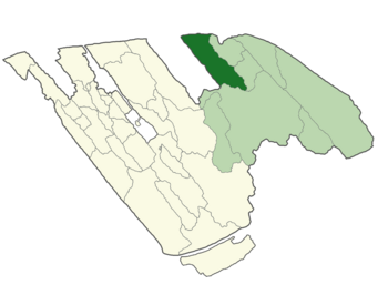
 Painshire in dark green, Eastern Modenshia in light green, and rest of Modenshia in beige. | |
| Demonym(s) | Shiric |
| Government | Monarchy |
• King | Spider |
• Prince | Yutrishi |
| Population | |
• Census | 3 |
| Capital | Greater Shireton |
|---|---|
| Largest city | East Drumchapel |
| Official languages | English, Spanish, High Britannian, Shiric, and Takayan. |
| Demonym | Shiric, Pantonian |
| Government | Monarchy |
| • King | Spider |
| • Queen | N/A |
| • Prince | Yutrishi |
| Legislature | Parliament |
| Establishment | 15th of November, 2022 |
| Population | |
| • Citizens | 3 |
| Currency | Pantonian Spleef ₽/ Shiric Pound Б |


